Senin, 28 Maret 2011
Surveying Definition

Surveying or land surveying is the technique and science of accurately determining the terrestrial or three-dimensional position of points and the distances and angles between them. These points are usually on the surface of the Earth, and they are often used to establish land maps and boundaries for ownership or governmental purposes.
To accomplish their objective, surveyors use elements of geometry, engineering, trigonometry, mathematics, physics, and law.
An alternative definition, per the American Congress on Surveying and Mapping (ACSM), is the science and art of making all essential measurements to determine the relative position of points and/or physical and cultural details above, on, or beneath the surface of the Earth, and to depict them in a usable form, or to establish the position of points and/or details.
Furthermore, as alluded to above, a particular type of surveying known as "land surveying" (also per ACSM) is the detailed study or inspection, as by gathering information through observations, measurements in the field, questionnaires, or research of legal instruments, and data analysis in the support of planning, designing, and establishing of property boundaries. It involves the re-establishment of cadastral surveys and land boundaries based on documents of record and historical evidence, as well as certifying surveys (as required by statute or local ordinance) of subdivision plats/maps, registered land surveys, judicial surveys, and space delineation. Land surveying can include associated services such as mapping and related data accumulation, construction layout surveys, precision measurements of length, angle, elevation, area, and volume, as well as horizontal and vertical control surveys, and the analysis and utilization of land survey data.
Surveying has been an essential element in the development of the human environment since the beginning of recorded history (about 5,000 years ago). It is required in the planning and execution of nearly every form of construction. Its most familiar modern uses are in the fields of transport, building and construction, communications, mapping, and the definition of legal boundaries for land ownership.
History of Surveying
The history of land surveying traces back to the separation of farm tracts and the flooding of the Nile River in Egypt. As the river would flood every year, there grew a need for markers to delineate the individual parcels. Stones were placed and geometric schemes devised so that if the river washed the markers away, they could be easily replaced.
As societies and forms of government became more complex, the need to divide parcels of land became more prevalent. In the early Eighteen Hundreds, our American government devised a system to divide the lands west of the original 13 colonies. This idea was more clearly defined in the form of the sectionalized land system, which remains in use today. This system allows for sections, townships and ranges. Each section is one mile square and 640 acres in area. Each township, measuring six miles by six miles, possesses 36 sections of land. As townships were created north and south, ranges were identified east and west.
After the Revolutionary War, our leaders used this method to sell forty acre-minimum tracts to affluent citizens as a way to rebuild the Treasury. In order to control the use of these smaller parcels, zoning was created. The zoning plan controlled land use so as to prevent the construction of, for example, a saloon next to a church; a brothel next to a school; or a heavy manufacturing plant next to a single-family residence.
Soon, a method of recording deeds and residential subdivisions was devised. Public records departments known as Register of Deeds or Clerk of Courts were created in courthouses throughout the nation. Abstracts of Title ( a history of each transaction with proper names and dates) were authored by attorneys. Abstracts of Title eventually became obsolete, being replaced by insurance documents known as "Title Insurance".
As lending institutions became more and more involved in the sale of land, property surveys became part of all real estate closings. Banking establishments must protect their investment by planning for a default in the mortgage. When they assume ownership of defaulted property and resell, they need to minimize complications. Boundary surveys provide protection against such complications, such as encroachments by neighbors over property lines, inadequate access to and from public streets, and unsettled property liens.
The purchase of a home or commercial real estate is a huge investment, and a boundary survey becomes a very inexpensive way for both owner and lender to insure the property title. Red Stake Surveyors, Inc. is proud to assist you with all of your land survey needs.
Types of Survey & Surveying Techniques
The techniques used for surveying and land measurement are dependent upon the type of survey being conducted. In this section there are two choices:
Types of survey
Techniques
Types of Survey
A simple classification is:
1. Land surveys, which fix property lines, calculate land areas and assist with the transfer of real property from one owner to another.
2. Engineering surveys, which collect the data needed to plan and design engineering projects. The information ensures the necessary position and dimension control on the site so that the structure is built in the proper place and as designed.
3. Informational surveys obtain data concerning topography, drainage and man-made features of a large area. This data is portrayed as maps and charts.
Another way to make a simple classification is:
1. Geodetic surveys are precise and over large areas require the curvature of the earth to be considered. Distances and angle measurements must be very, very accurate. A wide variety of techniques are used including triangulation, traversing, trilateration, levelling and astronomical direction fixing.
2. Plane surveys, which consider the surface of the earth to be a plane. Curvature is ignored and calculations are performed using the formulas of plane trigonometry and the properties of plane geometry. These may be considered accurate for limited areas.
Sub-categories of the major classes provide more insight into the various fields of surveying as follows:
· Property surveys determine boundary lines, property corners, rights-of-way provide data necessary for the preparation of land sub-divisions.
· Cadastral surveys are executed by the Federal Government in connection with the disposal of vast areas of land known as the public domain.
· Route surveys are necessary for the design and construction of various engineering projects such as roads, railways, pipelines, canals and powerlines.
· Industrial surveys, or optical metrology, are used in the aircraft and other industries where very accurate dimensional layouts are required.
· Topographic surveys are performed to gather data necessary to prepare topographic maps. These are multicolour contour maps portraying the terrain; and rivers; highways, railways, bridges and other man-made features.
· Hydrographic surveys map the shorelines of bodies of water; chart the bottom of streams, lakes, harbours and coastal waters; measure the flow of rivers; and assess other factors affecting navigation and water resources. The sounding of depths by radar is involved in this type of survey.
· Mine surveys determine the position of underground works such as tunnels and shafts, the position of surface structures and the surface boundaries.
· Aerial surveys use photogrammetry to produce a mosaic of matched vertical photographs, oblique views of landscape and topographic maps drawn from the photographs.
· Construction surveys fix elevations, horizontal positions and dimensions for construction projects.
· Control surveys provide basic horizontal and vertical position data. These are called datum. For most surveying work the vertical position of points in terms of height above a curved reference surface is mean sea level.
Techniques
1. Triangulation
2. Trilateration
3. Traverse
4. Leveling
5. Radiation
Triangulation
Triangulation consists of a series of connected triangles which adjoin or overlap each other, angles being measured from determined fixed stations. Triangulation reduces the number of measures that need to be taped and for this reason is often a preferred method of survey. A known base-line measurement is required. Three examples of triangulation systems are shown below.

A single chain of triangles is a rapid and economical system for covering a narrow strip of land. A chain of quadrilaterals is more accurate with checks being made by various combinations of angles and sides as the survey proceeds. Larger areas use a central point arrangement. A point to note is that all angles should be more than 20°. Angles less than 20° are not considered valid for fixing position. They introduce inaccuracies. This is much the same in navigation where a fix by two bearings requires an angle of intersection of approximately 90°, and for three bearings approximately 60°. Angles less than 30° are not acceptable.
Trilateration
Trilateration uses electronic distance measuring equipment to directly measure the lengths of the sides of triangles from which the angles can be calculated. It is a very useful method for rough terrain where positions can be accurately carried forward and is seen as an alternative method to triangulation.
Traverse
A traverse consists of a series of lines, whose lengths and directions are measured, connecting points whose positions are to be determined. The route of the traverse line can be adjusted for obstacles such as rough or timbered terrain, swampy land, buildings and areas of heavy traffic. A traverse may be either open or closed as shown below.

An open traverse begins at a point of known position and ends at a station whose relative position is unknown. This type of traverse is frequently used for preliminary surveys for highways. A closed traverse begins and ends at the same point whose position is known. An example of this type of traverse is a perimeter survey of a tract of land.
Leveling
Leveling is the operation of determining differences of elevation by measuring vertical distances directly on a graduated rod with the use of a leveling instrument such as a dumpy level, transit or Theodolites. This method is called direct leveling or differential leveling. Indirect leveling can be done using the principle that differences in elevation are proportional to the differences in atmospheric pressure. The difference in elevation between two points can also be determined trigonometrically using vertical angles and horizontal or inclined distances.
Differential leveling

Benchmarks are very important in leveling. They are permanent objects of known elevation located where there is least likelihood of disturbance. They may be a metal or concrete post set close to the ground, a notch in a tree root or a peg or spike in a tree.
Radiation
Radiation is a surveying technique often used in conjunction with a plane table. From a fixed position directly above the corresponding location on the ground bearings are taken to various points at the boundary of the survey area. The bearing lines are drawn on the paper on the table. Distances to the points are measured and then converted to the required scale on the survey sheet. Radiation surveying can be performed in a similar way directly on the ground taking bearings and distances from a fixed position and recording them for later work. Similarly plane table surveying may be used with other techniques such as a traverse or triangulation.
What Is Surveying?
Surveying Measurement:
The art, science, and technology of gathering and analyzing measurement data related to the land and other land-related surfaces and spaces, to include designing and devising the measurement specifications and standards to accomplish these measurements with the desired precision and accuracy and error control and adjustment, including the use of all instrumentation applicable to such measurements, said measurements typically being, but not limited to distances, heights, angles, directions, positions, areas, volumes, and other measurements associated with these quantities.
Professional Surveying:
The application of knowledge of the science of surveying measurement, the legal principles of boundary location, the laws related to boundaries and land use, the applicable mathematical and computational theories and principles, the natural and other forces which affect positional accuracy, the land planning and development concepts pertinent to subdivision of land and property surveys, land record and land tenure concepts, geodetic and other earth-related sciences to the analysis, design, and execution of surveying and mapping projects and the design of land mapping and information systems.
LOGICAL SCOPE OF PROFESSIONAL SURVEYING
1. Original Surveys for Establishing Property Boundaries
2. Retracement of Property Boundaries
3. Field Surveys for Topographic and other Maps
4. Photograrnmetric Surveys for Topographic and other Maps
5. Construction of Maps and other Graphics for Design and Planning
6. Layout and Staking to Guide Construction
7. Measuring and Plotting the Position of Constructed Works
8. Geodetic and other Precise Control Surveys
9. Surveys for Mining and other Subsurface Operations
10. Hydrographic and Underwater Surveys
11. Making Surveys and Maps for Land Information Systems
12. Design of Measurement Specifications for Various Surveys
13. Development of Measurement Standards for Various Surveys
14. Application, Use, and Adjustment of Measurement Instruments
15. Development of Relative Geometric Positional and other Accuracy Needs for Land Information Systems
16. Assisting Engineers, Lawyers, Planners, the Public, and Government Officials with the Solution of Problems Where Surveying Expertise is Needed
THE VALUE OF BEING A SURVEYOR:
Full understanding of the inexactness, uncertainty, and variable nature of measurement leads to humility since it teaches that one can never be sure of results. It is this very humility that, more than anything, creates the professional attitude needed to constantly seek new evidence, and consequently a higher probability of approaching the truth or proving something with confidence.
The surveyor is primarily an analyst. As an analyst of both measurement data and boundary location evidence (including geometric and other mathematical relationships) the surveyor is in a position to develop a keen sensitivity to the importance of finding and applying the truth.
A surveyor, when practicing according to the true nature of surveying, is ever seeking the truth, whether in measurement or in boundary location. Consequently, learning and applying the measurement science and the legal and other principles of boundary retracement develops character.
The art and science of surveying is a mirror of life itself.
Called "Geomatics" in Canada and much of Europe, land surveying is known as the world's second-oldest profession. It dates back to ancient Egypt and Babylonia. Surveying is essentially the art and science of measuring and mapping land. While the entire scope of our profession is vast, it all eventually boils down to determining where people's land boundaries are located. Without this service, railroads could not be built, skyscrapers could not be erected, and individuals could not put up fences around their yards, for fear of trespassing on someone else's land. Would you like an interstate highway to be built in your backyard, one you've paid for, maintained, and paid taxes on for years, without your permission? Of course, how would you know it was in your backyard without a surveyor to tell you where your property even was? We also stake out boundaries of roads to be built, monitor skyscrapers to make sure they are being erected vertically, and measure airports so that the runways are perfectly aligned and smooth. So, if you see a guy in the road looking through an instrument on a tripod, that is a surveyor, now you know that he is doing more than taking pictures.
What is a surveyor?
A surveyor is more than one of those guys you see out in the road. Surveying is a vital part of the design and construction process. We perform boundary surveys to tell people where their property is, map the topography of land for engineering design, establish elevations of home sites for flood insurance, perform title surveys for real estate transactions, certify that structures are built according to design, lay out buildings, subdivisions and other construction projects so the construction companies can relate the engineering plans to the real world, and build control networks that all land parcels can relate to in a given area. We also map slopes and areas for pay volumes or quantities, map river bottoms for dredging, lay out photo control for aerial photography and photogrammetry, write legal descriptions that are used to describe pieces of property, map and layout corridors for tunnels, roads, airports, pipelines, cellular networks and railroads, and split up properties into new lots, such as subdivisions.
Standard Surveying Units
- Acre - The (English) acre is a unit of area equal to 43,560 square feet, or 10 square chains, or 160 square poles. It derives from a plowing area that is 4 poles wide and a furlong (40 poles) long. A square mile is 640 acres. The Scottish acre is 1.27 English acres. The Irish acre is 1.6 English acres.
- Are -Non S>I Metric = 100 sq. metres
- Arpent - Unit of length and area used in France, Louisiana, and Canada. As a unit of length, approximately 191.8 feet (180 old French 'pied', or foot). The (square) arpent is a unit of area, approximately .845 acres, or 36,802 square feet.
- Cable - Imperial = 100 Fathoms. From the cable (Several ropes twisted together -very strong) used to secure ships at sea.
- Chain - Imperial = 4 poles = 22 yards. Attempt by Edmund Gunter (U.K. 1620's) to make land measure, a decimal system. His 66 foot chain had 100 links. , but possibly variant by locale. See also Rathbone's chain. The name comes from the heavy metal chain of 100 links that was used by surveyors to measure property bounds.
- Circle - One revolution = 360°
- Colpa - Old Irish measure of land equal to that which can support a horse or cow for a year. Approximately an Irish acre of good land.
- Degree - 60 nautical miles (latitude)
- Fathom - Imperial = 6 feet. From old english faethm.
- Foot - Imperial = 12 inches. Based on the length of the human foot.
- Engineer's Chain - A 100 foot chain containing 100 links of one foot apiece.
- Furlong - Unit of length equal to 40 poles (220 yards). Its name derives from "furrow long", the length of a furrow that oxen can plow before they are rested and turned. See Gunter's chain.
- Gunter's Chain - Unit of length equal to 66 feet, or 4 poles. Developed by English polymath Edmund Gunter early in the 1600's, the standard measuring chain revolutionized surveying. Gunter's chain was 22 yards long, one tenth of a furlong, a common unit of length in the old days. An area one chain wide by ten chains long was exactly an acre. In 1695 Queen Elizabeth I had the mile redefined from the old Roman value of 5000 feet to 5280 feet in order for it to be an even number of furlongs. A mile is 80 chains.
- Hectare - Metric unit of area equal to 10,000 square meters, or 2.471 acres, or 107,639 square feet.
- Hide - A very old English unit of area, a hide was of variable size depending on locale and the quality of the land. It was the amount of land to support a family, and ranged from 60 to 180 acres. After the Norman conquest in 1066 it became standardized at around 120 acres.
- Inch - Imperial. From old english (ynce) meaning one twelfth.
- Labor - The labor is a unit of area used in Mexico and Texas. In Texas it equals 177.14 acres (or 1 million square varas).
- League (legua) - Unit of area used in the southwest U.S., equal to 25 labors, or 4428 acres (Texas), or 4439 acres (California). Also, a unit of length-- approximately three miles.
- Link - Unit of length equal to 1/100 chain (7.92 inches).
- Mile - Imperial = 1760 yards = 8 furlongs From mille passum, a term used by the Roman armies of Caesar 'Mile' and 'pace'.
- Minute (1/60 of 1°) - 1 nautical mile (latitude)
- Morgen - Unit of area equal to about .6309 acres. It was used in Germany, Holland and South Africa, and was derived from the German word Morgen ("morning"). It represented the amount of land that could be plowed in a morning.
- Myriad - Historical (Greek) 1 myriad = 10 000 stadia
- Nautical mile - Used in marine and aeronautical navigation as 1nm = 1° (latitude)
- Octant (45°) - Historical. Meaning one eighth
- Out - An 'out' was ten chains. When counting out long lines, the chain carriers would put a stake at the end of a chain, move the chain and put a stake at the end, and so on until they ran "out" of ten stakes.
- Perch - See pole .
- Point - A point of the compass. There are four cardinal points (North, South, East, West), and 28 others yielding 32 points of 11.25 degrees each. A survey line's direction could be described as a compass point, as in "NNE" (north northeast). To improve precision, the points would be further subdivided into halves or quarters as necessary, for example, "NE by North, one quarter point North". In some areas, "and by" meant one half point, as in "NE and by North".
- Pole - Unit of length and area. Also known as a perch or rod. As a unit of length, equal to 16.5 feet. A mile is 320 poles. As a unit of area, equal to a square with sides one pole long. An acre is 160 square poles. It was common to see an area referred to as "87 acres, 112 poles", meaning 87 and 112/160 acres.
- Pueblo - A Spanish grant of less than 1000 acres.
- Quadrant (90°) - Historical. Meaning one quarter.
- Rancho - A Spanish grant of more than 1000 acres.
- Rathbone's Chain - A measuring chain two poles, or 33 feet, in length.
- Rod - See pole
- Rood - Unit of area usually equal to 1/4 acre.
- Sea league - Imperial = 3 nautical miles
- Sextant (60°) - Imperial = 3 nautical miles
- Stadia (Stade) - Historical (Greek) = 202 yards
- Vara - Unit of length (the "Spanish yard") used in the U.S. southwest. The vara is used throughout the Spanish speaking world and has values around 33 inches, depending on locale. The legal value in Texas was set to 33 1/3 inches early in the 1900's.
- Virgate - An old English unit of area, equal to one quarter of a hide. The amount of land needed to support a person.
- Yard - Imperial = 3 feet. From odl English gerd, or gierd (rod)
Standard Surveying Terms
- Aliquot - The description of fractional section ownership used in the U.S. public land states. A parcel is generally identified by its section, township, and range. The aliquot specifies its precise location within the section, for example, the northwest quarter of the southeast quarter.
- Azimuth - The number of degrees from north (or other reference direction) that a line runs, measured clockwise.
- Benchmark - A survey mark made on a monument having a known location and elevation, serving as a reference point for surveying.
- Call - Any feature, landmark, or measurement called out in a survey. For example, "two white oaks next to the creek" is a call.
- Chain carrier - An assistant to the surveyor, the chain carriers moved the surveying chain from one location to another under the direction of the surveyor. This was a position of some responsibility, and the chain carriers took an oath as "sworn chain carriers" that they would do their job properly.
- Condition - See Conditional line.
- Conditional line - An agreed line between neighbors that has not been surveyed, or which has been surveyed but not granted.
- Corner - The beginning or end point of any survey line. The term corner does not imply the property was in any way square.
- Declination - The difference between magnetic north and geographic (true) north. Surveyors used a compass to determine the direction of survey lines. Compasses point to magnetic north, rather than true north. This declination error is measured in degrees, and can range from a few degrees to ten degrees or more. Surveyors may have been instructed to correct their surveys by a particular declination value. The value of declination at any point on the earth is constantly changing because the location of magnetic north is drifting.
- First station - See Point of Beginning
- Gore - A thin triangular piece of land, the boundaries of which are defined by surveys of adjacent properties. Loosely, an overlap or gap between properties. See also strip.
- Landmark - A survey mark made on a 'permanent' feature of the land such as a tree, pile of stones, etc.
- Line Tree - Any tree that is on a property line, specifically one that is also a corner to another property.
- Mete - A limit point or mark. To butt up against.
- Metes and Bounds - An ancient surveying system that describes a parcel of land in terms of its relationship to natural features and adjacent parcels.
- Merestone - A stone that marks a boundary. See monument.
- Monument - A permanently placed survey marker such as a stone shaft sunk into the ground.
- Point of Beginning - The starting point of the survey
- Plat - A drawing of a parcel of land.
- Range - In the U.S. public land surveying system, a north-south column of townships, identified as being east or west of a reference longitudinal meridian, for example, Range 3 West. See township.
- Searles Spiral - A surveying technique used by railroad surveyors in the the late 1800s and early 1900s whereby they approximate a spiral by use of multiple curved segments.
- Section - In the U.S. public land surveying system, an area one mile square. See aliquot.
- Strip - A rectangular piece of land adjoining a parcel, created when a resurvey turns up a tiny bit larger than the original survey. The difference is accounted for by temperature or other effects on measuring chains. See also gore.
- Tie line - A survey line that connects a point to other surveyed lines.
- Township - In the U.S. public land surveying system, an area six miles square, containing 36 sections. The townships are organized in rows and are identified with respect to a reference latitudinal baseline, for example, Township 13 North. See range.
- Traverse - 1) any line surveyed across a parcel, 2) a series of such lines connecting a number of points, often used as a base for triangulation.
- Witness Tree - Generally used in the U.S. public land states, this refers to the trees close to a section corner. The surveyor blazed them and noted their position relative to the corner in his notebook. Witness trees are used as evidence for the corner location.
Surveying Slang
Surveying, like any profession, has its special terms and slang. Some are just humorous, some help distinguish similar sounds (e.g. eleven and seven), and some are just plain strange!
- Balls - Slang for numeric .00, as in 4-balls (4.00)
- Beep - Verb. To use a magnetic detector to look for iron pipe, etc.
- Boot - To raise the levels rod some number of inches so as to be visible to the instrument man, e.g. "Boot 6!" means "raise it 6 inches."
- Bullseye - Zero degrees of inclination.
- Burn - See shoot
- Burn one - Measure from the one foot mark on the tape rather than from the end of the tape in order to increase the accuracy of the measurement.
- Cut line - To clear vegetation for a line of sight between two survey control points.
- Double nickel - Slang for .55, as in 6-double nickel (6.55)
- Dummy or dummy-end - The base or zero end of a tape or chain, as in "hold dummy at the face of the curb."
- EDM - Electromagnetic Distance Measurement device, the instrument used by modern surveyors that replaces the use of measurement chains. It determines distance by measuring the time it takes for laser light to reflect off a prism on top of a rod at the target location.
- Ginney - A wooden dowel 6-9 inches in length with a sharpened end. Set in the ground to mark survey points.
- Glass - The EDM prism.
- Gun - Originally, a transit, but potentially any measurement instrument in use, e.g. theodolite, EDM, or Total Station.
- Hours - Degrees
- Hub and Tack - A 2" by 2" stake that is set in the ground and that contains a nail ("tack") that precisely marks the point being set.
- Legs - Tripod
- Pogo - Prism pole
- Punk - See railroad.
- Railroad - Slang for eleven, as in 42-railroad (42.11)
- Rodman - The person holding the rod with the EDM prism. This person is the modern version of a chain carrier or chain man.
- Shoot - Measure distance with an EDM
- Spike - Usually a 60 penny nail used to mark survey points in hard ground.
- Tie - To locate something with the transit or other measuring device.
- Top - Slang for eleven. See railroad.
- Trip - Slang for triple digits, as in trip5 means 555, and 43trip7 means 43.777
- Turn - The rodman is told to stay in place while the gun or level is moved to a new location.
- Zero - Zero degrees, minutes, and seconds. A perfect zero.
Surveying Water Terms
- Bank - Edge of a stream.
- Bed and banks - For property lines that cross a body of water, this term is used to explicitly refer to the bottom of the water.
- Bottom - Land along a river.
- Branch - Small stream.
- Brook - Small stream.
- Creek - Small stream.
- Drain - Small dry stream or gully.
- Drean - See drain.
- Ford - Shallow part of a stream or river where one could cross.
- Fork - Meeting point of two streams. "In the fork of" means between two branches.
- Gut - A narrow passage between hills. A stream in such a passage. A drain.
- Head - The source of a stream.
- Headwaters - The smallest streams that combine to make a larger stream.
- Kill - (Dutch) Creek.
- Lower - Toward the mouth of a stream. Further down along its course. Opposite of upper.
- Meander - "with the meanders of the stream" means the survey line follows the twists and turns of the stream.
- Mouth - The place where a stream enters another, larger stream.
- Narrows - Narrow part of a stream.
- River - Large stream.
- Run - Small stream.
- Shoal - Shallows.
- Spring - A pool or other source of water that feeds a stream.
- Swamp - In the southeastern U.S., a stream, particularly one that has has swampy parts. A marsh.
- Upper - Toward the head of a stream. Further up along its course. Opposite of lower.
- Vly - (Dutch) Swampy lowland.
- Waters ("watters") of - In the drainage of.
Standard Surveying Abbreviations
You might find the following corner descriptions on a plat drawing.
· FD - Found
· IPF - Iron pipe found
· IRF - Iron rod found
· L.O.D. - Limit of Disturbance. The area to be cleared, graded, etc.
· PK - Point Known
· PK nail - A surveyor's nail that marks a survey point. See also hub and tack.
· SR - Steel rebar
· SRS - Steel rod set (rebar or other steel)
Soil Mechanics Definition

Soil mechanics is a branch of engineering mechanics that describes the behavior of soils. It differs from fluid mechanics and solid mechanics in the sense that soils consist of a heterogeneous mixture of fluids (usually air and water) and particles (usually clay, silt, sand, and gravel) but soil may also contain organic solids, liquids, and gasses and other matter. Along with rock mechanics, soil mechanics provides the theoretical basis for analysis in geotechnical engineering , a subdiscipline of Civil engineering. Soil mechanics is used to analyze the deformations of and flow of fluids within natural and man-made structures that are supported on or made of soil, or structures that are buried in soils . Examples applications are building and bridge foundations, retaining walls, dams, and buried pipeline systems. Principles of soil mechanics are also used in related disciplines such as geophysical engineering, engineering geology, coastal engineering, agricultural engineering, hydrology and soil physics.
Genesis of Soils
Genesis
The primary mechanism of soil creation is the weathering of rock. All rock types (igneous rock, metamorphic rock and sedimentary rock) may be broken down into small particles to create soil. Weathering mechanisms are physical weathering, chemical weathering, and biological weathering Human activities such as excavation, blasting, and waste disposal, may also create soil. Over geologic time, deeply buried soils may be altered by pressure and temperature to become metamorphic or sedimentary rock, and if melted and solidified again, they would complete the geologic cycle by becoming igneous rock.
Physical weathering includes temperature effects, freeze and thaw of water in cracks, rain, wind, impact and other mechanisms. Chemical weathering includes dissolution of matter composing a rock and precipitation in the form of another mineral. Clay minerals, for example can be formed by weathering of feldspar, which is the most common mineral present in igneous rock.
The most common mineral constituent of silt and sand is quartz, also called silica, which has the chemical name silicon dioxide. The reason that feldspar is most common in rocks but silicon is more prevalent in soils is that feldspar is much more soluble than silica.
Silt, Sand, and Gravel are basically little pieces of broken rocks.
According to the Unified Soil Classification System, silt particle sizes are in the range of 0.002 mm to 0.075 mm and sand particles have sizes in the range of 0.075 mm to 4.75 mm.
Gravel particles are broken pieces of rock in the size range 4.75 mm to 100 mm.
Particles larger than gravel are called cobbles and boulders.
Transport
Soil deposits are affected by the mechanism of transport and deposition to their location. Soils that are not transported are called residual soils -- they exist at the same location as the rock from which they were generated. Decomposed granite is a common example of a residual soil. The common mechanisms of transport are the actions of gravity, ice, water, and wind. Wind blown soils include dune sands and loess. Water carries particles of different size depending on the speed of the water, thus soils transported by water are graded according to their size. Silt and clay may settle out in a lake, and gravel and sand collect at the bottom of a river bed. Wind blown soil deposits (aeolian soils) also tend to be sorted according to their grain size. Erosion at the base of glaciers is powerful enough to pick up large rocks and boulders as well as soil; soils dropped by melting ice can be a well graded mixture of widely varying particle sizes. Gravity on its own may also carry particles down from the top of a mountain to make a pile of soil and boulders at the base; soil deposits transported by gravity are called colluvium.
The mechanism of transport also has a major effect on the particle shape. For example, low velocity grinding in a river bed will produce rounded particles. Freshly fractured colluvium particles often have a very angular shape.
Composition of Soil
Soil composition
Soil mineralogy
Silts, sands and gravels are classified by their size, and hence they may consist of a variety of minerals. Owing to the stability of quartz compared to other rock minerals, quartz is the most common constituent of sand and silt . Mica, and feldspar are other common minerals present in sands and silts . The mineral constituents of gravel may be more similar to that of the parent rock.
The common clay minerals are montmorillonite or smectite, illite, and kaolinite or kaolin. These minerals tend to form in sheet or plate like structures, with length typically ranging between 10 − 7m and 4x10 − 6m and thickness typically ranging between 10 − 9m and 2x10 − 6m, and they have a relatively large specific surface area. The specific surface area (SSA) is defined as the ratio of the surface area of particles to the mass of the particles. Clay minerals typically have specific surface areas in the range of 10 to 1,000 square meters per gram of solid . Due to the large surface area available for chemical, electrostatic, and van der Waals interaction, the mechanical behavior of clay minerals is very sensitive to the amount of pore fluid available and the type and amount of dissolved ions in the pore fluid.
The minerals of soils are predominantly formed by atoms of oxygen, silicon, hydrogen, and aluminum, organized in various crystalline forms. These elements along with calcium, sodium, potassium, magnesium, and carbon constitute over 99 per cent of the solid mass of soils.
Grain size distribution
Soils consist of a mixture of particles of different size, shape and mineralogy. Because the size of the particles obviously has a significant effect on the soil behavior, the grain size and grain size distribution are used to classify soils. The grain size distribution describes the relative proportions of particles of various sizes. The grain size is often visualized in a cumulative distribution graph which, for example, plots the percentage of particles finer than a given size as a function of size. The median grain size, D50, is the size for which 50% of the particle mass consists of finer particles. Soil behavior, especially the hydraulic conductivity, tends to be dominated by the smaller particles, hence, the term "effective size", denoted by D10, is defined as the size for which 10% of the particle mass consists of finer particles.
Sands and gravels that possess a wide range of particle sizes with a smooth distribution of particle sizes are called well graded soils. If the soil particles in a sample are predominantly in a relatively narrow range of sizes, the soil are called uniformly graded soils. If there are distinct gaps in the gradation curve, e.g., a mixture of gravel and fine sand, with no coarse sand, the soils may be called gap graded. Uniformly graded and gap graded soils are both considered to be poorly graded. There are many methods for measuring particle size distribution. The two traditional methods used in geotechnical engineering are sieve analysis and hydrometer analysis.
Sieve analysis
The size distribution of gravel and sand particles are typically measured using sieve analysis. The formal procedure is described by ASTM (number needed). A stack of sieves with accurately dimensioned holes between a mesh of wires is used to separate the particles into size bins. A known volume of dried soil, with clods broken down to individual particles, is put into the top of a stack of sieves arranged from coarse to fine. The stack of sieves is shaken for a standard period of time so that the particles are sorted into size bins. This method works reasonably well for particles in the sand and gravel size range. Fine particles tend to stick to each other, and hence the sieving process is not an effective method. If there are a lot of fines (silt and clay) present in the soil it may be necessary to run water through the sieves to wash the coarse particles and clods through.
A variety of sieve sizes are available. The boundary between sand and silt is arbitrary. According to the Unified Soil Classification System, a #4 sieve (4 openings per inch) having 4.75mm opening size separates sand from gravel and a #200 sieve with an 0.075 mm opening separates sand from silt and clay. According to the British standard, 0.063 mm is the boundary between sand and silt, and 2 mm is the boundary between sand and gravel.
Hydrometer analysis
The classification of fine-grained soils, i.e., soils that are finer than sand, is determined primarily by their Atterberg limits, not by their grain size. If it is important to determine the grain size distribution of fine-grained soils, the hydrometer test may be performed. In the hydrometer tests, the soil particles are mixed with water and shaken to produce a dilute suspension in a glass cylinder, and then the cylinder is left to sit. A hydrometer is used to measure the density of the suspension as a function of time. Clay particles may take several hours to settle past the depth of measurement of the hydrometer. Sand particles may take less than a second. Stoke's law provides the theoretical basis to calculate the relationship between sedimentation velocity and particle size. ASTM provides the detailed procedures for performing the Hydrometer test.
Clay particles can be sufficiently small that they never settle because they are kept in suspension by Brownian motion, in which case they may be classified as colloids.
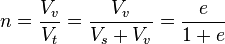
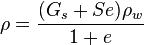
Mass-volume relations

There are a variety of parameters used to describe the relative proportions of air, water and solid in a soil. This section defines these parameters and some of their interrelationships . The basic notation is as follows:
Va, Vw, and Vs represent the volumes of air, water and solids in a soil mixture;
Wa, Ww, and Ws represent the weights of air, water and solids in a soil mixture;
Ma, Mw, and Ms represent the masses of air, water and solids in a soil mixture;
ρa, ρw, and ρs represent the densities of the constituents (air, water and solids) in a soil mixture;
Note that the weights, W, can be obtained by multiplying the mass, M, by the acceleration due to gravity, g; e.g., Ws = Msg
Specific Gravity is the ratio of the density of one material compared to the density of pure water (ρw = 1g / cm3).
Specific gravity of solids,
Note that unit weights, conventionally denoted by the symbol γ may be obtained by multiplying the density instead of ρ by the acceleration due to gravity, g.
Density, Bulk Density, or Wet Density, ρ, are different names for the density of the mixture, i.e., the total mass of air, water, solids divided by the total volume of air water and solids (the mass of air is assumed to be zero for practical purposes):
Water Content, w is the ratio of mass of water to mass of solid. It is easily measured by weighing a sample of the soil, drying it out in an oven and re-weighing. Standard procedures are described by ASTM.
Wa, Ww, and Ws represent the weights of air, water and solids in a soil mixture;
Ma, Mw, and Ms represent the masses of air, water and solids in a soil mixture;
ρa, ρw, and ρs represent the densities of the constituents (air, water and solids) in a soil mixture;
Note that the weights, W, can be obtained by multiplying the mass, M, by the acceleration due to gravity, g; e.g., Ws = Msg
Specific Gravity is the ratio of the density of one material compared to the density of pure water (ρw = 1g / cm3).
Specific gravity of solids,
Note that unit weights, conventionally denoted by the symbol γ may be obtained by multiplying the density instead of ρ by the acceleration due to gravity, g.
Density, Bulk Density, or Wet Density, ρ, are different names for the density of the mixture, i.e., the total mass of air, water, solids divided by the total volume of air water and solids (the mass of air is assumed to be zero for practical purposes):


Water Content, w is the ratio of mass of water to mass of solid. It is easily measured by weighing a sample of the soil, drying it out in an oven and re-weighing. Standard procedures are described by ASTM.


Engineering Mechanics Statics
Introduction
Engineering statics is often the first topic of study, within the more general discipline of engineering mechanics. It is fundamental (but not limited to) most branches of engineering, including aerospace, aeronautical, civil, electrical, and mechanical engineering. It is also the basis for more advanced study in dynamics, vibration, and mechanics of materials within civil engineering, engineering mechanics, and mechanical engineering.
Engineering statics is often the first topic of study, within the more general discipline of engineering mechanics. It is fundamental (but not limited to) most branches of engineering, including aerospace, aeronautical, civil, electrical, and mechanical engineering. It is also the basis for more advanced study in dynamics, vibration, and mechanics of materials within civil engineering, engineering mechanics, and mechanical engineering.
Prerequisites
Prerequisites for studying statics include a background in calculus and engineering physics. Students will make use of the mathematical principles learned in calculus and analytical geometry, as well as the classical mechanics principles studied in physics. In reality, much of statics is an extension of physics principles applied to engineering structures.
Prerequisites for studying statics include a background in calculus and engineering physics. Students will make use of the mathematical principles learned in calculus and analytical geometry, as well as the classical mechanics principles studied in physics. In reality, much of statics is an extension of physics principles applied to engineering structures.
Definition
Engineering mechanics statics is a fundamental building block to a clear understanding of forces and motion in real-world engineering applications. Statics deals with of the forces and interactions that occur in rigid bodies that are in static equilibrium. It is the analysis of how two and three-dimensional simple structures react and support applied loads.
Engineering mechanics statics is a fundamental building block to a clear understanding of forces and motion in real-world engineering applications. Statics deals with of the forces and interactions that occur in rigid bodies that are in static equilibrium. It is the analysis of how two and three-dimensional simple structures react and support applied loads.
Topics of Study
During the study of statics, the student will learn how to resolve forces, moments, and couples to achieve equilibrium in stationary structures. The calculation of centers of gravity, properties of plane areas, and moments of inertia will form the basis for further study in dynamics and engineering mechanics of materials. Additional topics include vector analysis, particle equilibrium, distributed forces, and internal forces in structural members. Finally, the analysis of friction in structures, and the concepts of virtual work typically conclude the study of engineering statics.
During the study of statics, the student will learn how to resolve forces, moments, and couples to achieve equilibrium in stationary structures. The calculation of centers of gravity, properties of plane areas, and moments of inertia will form the basis for further study in dynamics and engineering mechanics of materials. Additional topics include vector analysis, particle equilibrium, distributed forces, and internal forces in structural members. Finally, the analysis of friction in structures, and the concepts of virtual work typically conclude the study of engineering statics.
Vector Analysis (Vector Mechanics)
Vector analysis is a critical skill that will be used throughout the study of engineering statics. It is often convenient to resolve a single force into two distinct forces. Known as components, these forces, when acting together, have the same external effect on a body as the original force (the resultant). This process is derived from the study of physics, and is called vector analysis or vector mechanics. When forces are being represented as vectors, it is important to show a clear distinction between a resultant and its components. The resultant could be shown with color or as a solid line and the components shown as dashed lines, or vice versa.
Vector analysis is a critical skill that will be used throughout the study of engineering statics. It is often convenient to resolve a single force into two distinct forces. Known as components, these forces, when acting together, have the same external effect on a body as the original force (the resultant). This process is derived from the study of physics, and is called vector analysis or vector mechanics. When forces are being represented as vectors, it is important to show a clear distinction between a resultant and its components. The resultant could be shown with color or as a solid line and the components shown as dashed lines, or vice versa.
Free Body Diagrams (FBD's)
Experience has shown that drawing Free Body Diagrams (FBDs) is the most important skill needed for solving engineering mechanics problems. By emphasizing the importance of visual analysis, text discussion, and homework problems, students will learn that drawing free body diagrams will greatly benefit their engineering education. Further study in dynamics and mechanics of materials is strongly tied to the concept of free body diagrams.
Experience has shown that drawing Free Body Diagrams (FBDs) is the most important skill needed for solving engineering mechanics problems. By emphasizing the importance of visual analysis, text discussion, and homework problems, students will learn that drawing free body diagrams will greatly benefit their engineering education. Further study in dynamics and mechanics of materials is strongly tied to the concept of free body diagrams.
Simple Structures
In engineering mechanics, an arrangement of rigid members connected in specific patterns is called a structure. A bridge, a communication tower, and the frame of an automobile all are considered structures. Simple structures include plane and space trusses, beams, frames, and machines. These simple structures are the types that are studied in engineering statics. For instance, the method of joints is a method that is used to determine the forces in each member of a simple truss or space frame.
In engineering mechanics, an arrangement of rigid members connected in specific patterns is called a structure. A bridge, a communication tower, and the frame of an automobile all are considered structures. Simple structures include plane and space trusses, beams, frames, and machines. These simple structures are the types that are studied in engineering statics. For instance, the method of joints is a method that is used to determine the forces in each member of a simple truss or space frame.
Instructional Aids
There are many instructional aids that can help the student or engineer understand the principles of engineering mechanics statics. Example problems and homework are probably the best teaching aid because they illustrate the application of fundamental theory to practical engineering problems. Graphical methods of force resolution were developed before the turn of the century, but are still applicable today. Photos that show the connection between physical situations and their mathematical simulations are very helpful. Video and tutorial animations that are available online illustrate statics in a unique teaching format. Optional MATLAB and MathCAD worksheets online are also helpful, as well as solution manuals
There are many instructional aids that can help the student or engineer understand the principles of engineering mechanics statics. Example problems and homework are probably the best teaching aid because they illustrate the application of fundamental theory to practical engineering problems. Graphical methods of force resolution were developed before the turn of the century, but are still applicable today. Photos that show the connection between physical situations and their mathematical simulations are very helpful. Video and tutorial animations that are available online illustrate statics in a unique teaching format. Optional MATLAB and MathCAD worksheets online are also helpful, as well as solution manuals
Selasa, 08 Maret 2011
History Of The Civil Engineering Profession
Engineering has been an aspect of life since the beginnings of human existence. The earliest practices of Civil engineering may have commenced between 4000 and 2000 BC in Ancient Egypt and Mesopotamia (Ancient Iraq) when humans started to abandon a nomadic existence, thus causing a need for the construction of shelter. During this time, transportation became increasingly important leading to the development of the wheel and sailing.
Until modern times there was no clear distinction between civil engineering and architecture, and the term engineer and architect were mainly geographical variations referring to the same person, often used interchangeably. The construction of Pyramids in Egypt (circa 2700-2500 BC) might be considered the first instances of large structure constructions. Other ancient historic civil engineering constructions include the Parthenon by Iktinos in Ancient Greece (447-438 BC), the Appian Way by Roman engineers (c. 312 BC), the Great Wall of China by General Meng T'ien under orders from Ch'in Emperor Shih Huang Ti (c. 220 BC) and the stupas constructed in ancient Sri Lanka like the Jetavanaramaya and the extensive irrigation works in Anuradhapura. The Romans developed civil structures throughout their empire, including especially aqueducts, insulae, harbours, bridges, dams and roads.

In the 18th century, the term civil engineering was coined to incorporate all things civilian as opposed to military engineering. The first self-proclaimed civil engineer was John Smeaton who constructed the Eddystone Lighthouse. In 1771 Smeaton and some of his colleagues formed the Smeatonian Society of Civil Engineers, a group of leaders of the profession who met informally over dinner. Though there was evidence of some technical meetings, it was little more than a social society.
In 1818 the Institution of Civil Engineers was founded in London, and in 1820 the eminent engineer Thomas Telford became its first president. The institution received a Royal Charter in 1828, formally recognising civil engineering as a profession. Its charter defined civil engineering as:
the art of directing the great sources of power in nature for the use and convenience of man, as the means of production and of traffic in states, both for external and internal trade, as applied in the construction of roads, bridges, aqueducts, canals, river navigation and docks for internal intercourse and exchange, and in the construction of ports, harbours, moles, breakwaters and lighthouses, and in the art of navigation by artificial power for the purposes of commerce, and in the construction and application of machinery, and in the drainage of cities and towns.
The first private college to teach Civil Engineering in the United States was Norwich University founded in 1819 by Captain Alden Partridge. The first degree in Civil Engineering in the United States was awarded by Rensselaer Polytechnic Institute in 1835. The first such degree to be awarded to a woman was granted by Cornell University to Nora Stanton Blatch in 1905.
(source: Wikipedia, the free encyclopedia)
Langganan:
Postingan (Atom)